More and more web applications using Angular today need a kind of map, either to just display their location, or visualize their data. These data can be from points/locations of services/places/etc, or a user input, to more complex visuals like heatmaps or paths. These visualizations can easily be achieved with OpenLayers open source library, or even the Google Maps JS API. However, the integration with Angular and the use of its tools is not always straightforward. In this presentation I will show examples of how to integrate OpenLayers and Google Maps easily into your Angular application without the use of any external libraries. Part of the presentation will also show some techniques for visualising spatial data on these maps.
More Talks by Katerina

VideoGeneral Info
From Buildings to Software – Paving the way to construction
TopicsJavaScript, Web & Mobile
As an architectural engineer by training, and working as a web dev for the past...
Discover More Talks
More talks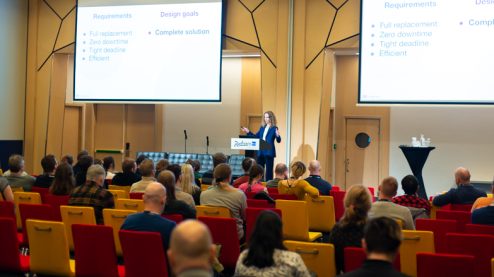
VideoGeneral Info
CHANGE WINGS ON THE FLY: HOW WE REPLACED A SYSTEM THAT HANDLES SEVERAL MILLION EURO TURNOVER WITH ZERO DOWNTIME.
DisciplinesProduct Design, User Experience
TopicsDesign Strategy, Design Thinking, Product Development
IndustryFinance
Speaker Tatiana Chernogorova
In October 2019 Diggecard, a Norwegian fintech startup, acquired a UK gift card...

General Info
The Design of Business | The Business of Design S2E9: Ashleigh Axios
DisciplineBrand
TopicsCareer, Leadership
IndustryGovernment
Speaker Ashleigh Axios
Ashleigh Axios is the design exponent at Automattic and a former creative director...

VideoGeneral Info
Meeting at the Intersection of Content Strategy and UX Design
DisciplinesContent Strategy, User Experience
TopicsTeamwork
Speaker Marli Mesibov
Let’s talk about content strategy. Let’s talk about UX design. Let’s talk about...
Speakers, Get Featured
Get connected with event organizers interested in engaging women and gender non-binary speakers in design and tech.
Sign UpAlready have an account?
Log inKnow a great speaker? Let us know so we can invite them to be part of our directory and amplify their voice.
Nominate them